
The fourth eruption of 2017 of Volcán de Fuego, Guatemala, began in the morning of Thursday 4th May. The national monitoring institute, INSIVUMEH, released several special bulletins providing information as the eruption progressed. The early stages included the development of two lava flows, in the Santa Teresa and Las Lajas river valleys; by 21:30 local time the flows had reached approximately 2,000 metres and 1,000 metres in length, respectively (Source). By the morning of Friday 5th May, Fuego had generated an eruption column that reached approximately 6,000 metres above sea level, and ash had fallen on communities on the southern flanks of the volcano (Source). The activity prompted the national disaster response services, CONRED, to issue an orange alert (elevated risk) and to evacuate the inhabitants of Sangre de Cristo, a homestead of 30 inhabitants, to another homestead further from the volcano (Source).
The eruption has been comprehensively documented on Twitter (particularly by @gchigna and @William_Chigna). The eruption was also covered by national press such as Prensa Libre, for instance here. The most impressive image of the eruption, I think, is the one directly below, shared by Carla Quinillo of INSIVUMEH (@v_ainilli7a). It shows the Santa Teresa valley first in February and then in May, before and after a pyroclastic flow moved through it.

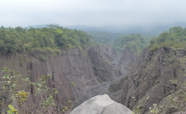
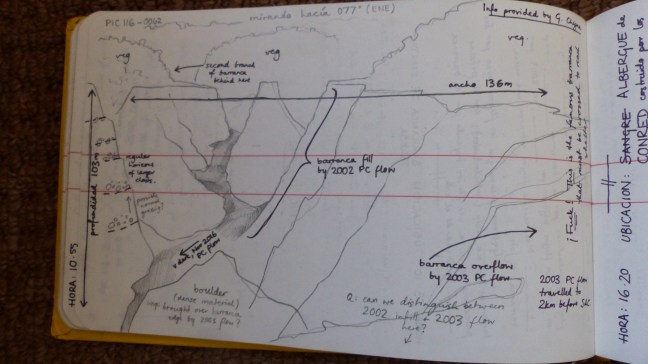
I think this image is astounding. I visited that valley on February 22nd, when I was demonstrating for the university’s MSc Volcanology field course. I remember standing close to that peninsula, where the volcanologist is crouched, and staring into the deep ravine in front of me. We were lucky to be accompanied by Gustavo Chigna, the foremost volcanologist in Guatemala (I’ve linked his Twitter account above). Gustavo estimated then that the valley was 103 metres deep, and 136 metres broad. He told us the recent history of the valley. He explained that in 2002, an eruption of Fuego had released a powerful pyroclastic flow, which had travelled to where we were stood. (A pyroclastic flow is a fast-moving, hot, dense current of volcanic gases, ash, and pulverized rock.) The flow had filled the valley. In 2003 another eruption released a pyroclastic flow of roughly equivalent energy; as it travelled to the lower slopes of the volcano it did not meet a deep, wide valley, as the 2002 flow had done; instead, the 2003 flow reached a shallow depression, recently filled in by volcanic deposits. As the 2003 flow still had energy to expend, it leapt the remaining height of the valley bank, and roared down the volcano’s slopes, consuming plants and trees in its way. On February 22nd 2017, the thick jungle in which we began our walk eventually thinned and gave way to young shoots and spindly trees. This was the young vegetation that had grown after the 2003 pyroclastic flow had been laid down.
It is incredible to imagine the power of a pyroclastic flow, that can travel many kilometres in a few minutes, and leap the side of a ravine. If another pyroclastic flow descends the Santa Teresa valley, a situation similar to 2002 – 2003 may happen again, and higher land surrounding the valley is damaged. However, the recent pyroclastic flow may be eroded before another flow descends. While this seems like the favourable alternative, it has potential consequences. Rainfall would erode the flow; rain mixed with volcanic deposits generates mudflows known as lahars. Due to its steep flanks and the heavy rainfall of the region, Fuego creates powerful lahars (see this video). These could travel downstream and cause great damage; already it has been reported that there has been damage to the country road that unites the highway with the villages of Panimache and Morelia, and the Fuego observatory (Source).
It will be extremely interesting to see how the aftermath of this eruption affects the surroundings of Fuego. For a brief taste of what the valley used to look like, I leave you with some of my notes from the field, and a photograph. Enjoy!
Date: Feb 22, 2017
Time: 13:10
Location: Barranca de Santa Teresa
Notes from Matt Watson and Gustavo Chigna: Eruption of January 2002 released pyroclastic flow that completely filled the centre of Barranca de Santa Teresa. In June 2003, another eruption released pyroclastic flows that descended the same barranca; but as it was already filled by deposits from 2002, the flow in 2003 overtopped the bank.

[Above – the ledge on which the volcanologist is standing in the After photo of 09/05/17 can just be seen on the far right-hand side of this picture, to the right of the young tree.]
Time: 16:20
Location: CONRED evacuation shelter provided for the inhabitants of Sangre de Cristo.
Notes from Francisco:

I think the notes above highlight some of the many factors involved in the extremely difficult task of improving volcanic risk mitigation in a developing country like Guatemala. If you can get your hands on it, I recommend this paper, that delves into the ways that people perceive risk and hazard. If you’re more interested in the physical volcanology side, INSIVUMEH update their site with regular bulletins if Fuego is active.
